Enregistrez gratuitement cette image
en 800 pixels pour usage maquette
(click droit, Enregistrer l'image sous...)
|
|
Réf : T01380
Thème :
Terre vue de l'espace - Déserts - Dunes (200 images)
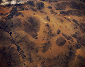
Titre : Whipple Mountains, Southern California, U.S.A. June 1991
Description : (La description de cette image n'existe qu'en anglais)
A part of the Colorado River that forms the boundary between California and Arizona is evident near the eastern edge (left side) of the photograph. Irrigated agriculture field patterns are visible in two distinct floodplains along the river. The Whipple Mountains create an eastern protrusion of land that noticeably changes the course of the river. The northwest-southeast-trending Chemehuevi Mountains lie north of the Whipple Mountains, paralleling the Colorado River in California. Parker Dam (beyond the scope of the photograph) on the Colorado River created Lake Havasu, identified by the narrow peninsula that juts southeastward into the Colorado River. Color changes around the bases of the mountains provide visual evidence of erosion. Small segments of Interstate Highway 40 appear in a general east-west alignment.
|
|

